Island-on-Map.com The Free Beach Guide HomeCountriesMenu

Vieques island

Ultimate guide (January 2025)
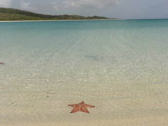
Vieques - island in Puerto Rico - not far from the Big island. The island has excellent beaches and bioluminescent bay where the water shines at night. For a long time a large area of the island was occupied by the U.S. military base, so tourist development has been delayed. Therefore, the island has well preserved nature. Some parts of the island are closed to tourists due to the risk of bomb explosion. Beach and seabed: sand. [edit]
This island ranks #14 of the "Best islands in the Caribbean"
Rating: 8.6 - 692 votes [vote]
Coordinates: 18.127255, -65.426384
See also: Best beaches in Vieques island

Hotels [edit]

The island has several hotels and guesthouses, most of which are not presented in international booking systems. Also near the Sun Bay beach there is a campsite where you can settle in your tent.

How to get there [edit]

Fly to San Juan airport (SJU). Next get to Fajardo ferry dock by taxi or by bus. Boats to Vieques island run several times per day.

When to go [edit]

Feel free to visit Vieques island any time of year. There is a small chance of hurricanes in the summer, but sea water is warmer. Winter is considered to be a high season, and there are a lot of people that time.

Rainfall, mm
Rainfall, mm

Water temperature, C

Temperature, C
Temperature, C

Humidity, %
Humidity, %

Wind speed, meter/sec

Useful information [edit]

The best beaches are located near a southern Esperanza town. There are several shops in a town with a poor choice of products. Good supermarket is only in Isabel Segunda town, which has ferry port serving boats from the Big Island.

Open map

See also other islands nearby:

 
Puerto Rico, Culebra island, Playa Carlos Rosario beach 8.3
26 km to the north-east
Location: Caribbean, Puerto Rico
Rating: 8.3 (1101 votes)
American Virgin Islands (USVI), St. Thomas island, Lindberg Bay beach 8.4
57 km to the north-east
Location: Caribbean, USVI
Rating: 8.4 (967 votes)
USVI, St. John island, Maho Bay beach, palms 8.7
77 km to the east
Location: Caribbean, USVI
Rating: 8.7 (801 votes)
British Virgin Islands (BVI), Jost Van Dyke island, White Bay 8.9
80 km to the north-east
Location: Caribbean, BVI
Rating: 8.9 (810 votes)
BVI, Beef Island, Tortola airport, aerial view 8.3
100 km to the east
Location: Caribbean, BVI
Rating: 8.3 (1130 votes)
💖
If you liked this page, please share it on: Facebook, Twitter, Instagram
…or any other web-site
 
This will help the project greatly!

 
To the top of this page »
 
© 2025, Island-on-Map.com · Menu