Island-on-Map.com The Free Beach Guide HomeCountriesMenu

Ngerukewid islands

Ultimate guide (January 2025)
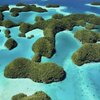
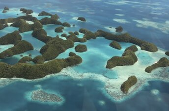
Ngerukewid is a group of islands in the southwest of Palau. It has about twenty islets of different size, but no beaches at all. Moreover, it won't be so easy just to get to the shore. Boat tours are quite rare here. Anyway there are more decent islands located closer to Koror. So scenic flight is the main option to visit this place. Shore and seabed: rocks, sand. [edit]
This island ranks #9 of the "Best islands in Palau"
Rating: 7.7 - 1 vote [vote]
Coordinates: 7.177559, 134.264531

Hotels [edit]

There are no hotels in Ngerukewid Islands, while camping is prohibited.

How to get there [edit]

Fly to Palau international airport (ROR). Next take a taxi or get by bus to the neighboring island of Koror. Next get by boat to Ngerukewid island.

When to go [edit]

The best time for a beach holiday in Palau is a dry season from February to April.

Rainfall, mm
Rainfall, mm

Water temperature, C

Temperature, C
Temperature, C

Humidity, %
Humidity, %

Wind speed, meter/sec

Open map

See also other islands nearby:

 
Palau, Uncle Island, beach 8.1
6.7 km to the south-east
Location: Oceania, Palau
Rating: 8.1 (6 votes)
Palau, Omekang island 8.3
7.1 km to the south-east
Location: Oceania, Palau
Rating: 8.3 (8 votes)
Palau, Mecherchar island 8.4
11 km to the east
Location: Oceania, Palau
Rating: 8.4 (6 votes)
Palau, Euidelchol island, beach 8.0
12 km to the east
Location: Oceania, Palau
Rating: 8.0 (8 votes)
Palau, Ulong island, beach, boat 8.2
12 km to the north
Location: Oceania, Palau
Rating: 8.2 (34 votes)
💖
If you liked this page, please share it on: Facebook, Twitter, Instagram
…or any other web-site
 
This will help the project greatly!

 
To the top of this page »
 
© 2025, Island-on-Map.com · Menu