Island-on-Map.com The Free Beach Guide HomeCountriesMenu

Fernando de Noronha islands

Ultimate guide (December 2024)
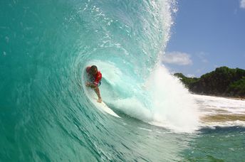
Fernando de Noronha - brazilian archipelago of islands in the Atlantic Ocean located to the south of the equator. There are some good beaches here. Also coast line is well suited for surfing. Shore and seabed: sand, stones. [edit]
This island ranks #3 of the "Best islands in Brazil"
Rating: 8.0 - 458 votes [vote]
Coordinates: -3.84403, -32.424899
See also: Best beaches in Fernando de Noronha

Hotels [edit]

Almost all the hotels are located in the northern part of the island. The average price level is very high.

How to get there [edit]

Fly to Brazil to one of airports: Sao Paulo - Guarulhos International Airport (GRU) or Rio de Janeiro International Airport (GIG). Next fly to Fernando de Noronha Airport (FEN).

When to go [edit]

Any time of year. We advice to avoid April, as this is the most rainy time.

Rainfall, mm
Rainfall, mm

Water temperature, C

Temperature, C
Temperature, C

Humidity, %
Humidity, %

Wind speed, meter/sec

Open map

See also other islands nearby:

 
Brazil, Morro de Sao Paulo island, Segunda Praia beach 8.3
1280 km to the south-west
Location: South America, Brazil
Rating: 8.3 (716 votes)
Brazil, Boipeba island, Praia de Bainema beach 8.7
1300 km to the south-west
Location: South America, Brazil
Rating: 8.7 (207 votes)
Cape Verde, Boa Vista island, Santa Maria beach, shipwreck 6.9
2460 km to the north-east
Location: Africa, Cape Verde
Rating: 6.9 (2922 votes)
Cape Verde, Sal island, clear water 7.6
Sal / open » /
2510 km to the north-east
Location: Africa, Cape Verde
Rating: 7.6 (1197 votes)
Brazil, Santa Catarina isl, Ilha do Campeche beach 7.9
3150 km to the south-west
Location: South America, Brazil
Rating: 7.9 (1618 votes)
💖
If you liked this page, please share it on: Facebook, Twitter, Instagram
…or any other web-site
 
This will help the project greatly!

 
To the top of this page »
 
© 2024, Island-on-Map.com · Menu