Island-on-Map.com The Free Beach Guide HomeCountriesMenu

Aratika atoll

Ultimate guide (October 2024)
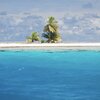
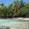
Aratika is an atoll to the east of Rangiroa Atoll in French Polynesia. This is not very interesting place. However, it has a nice lagoon with paradise sandbanks. Most beaches are rocky with uncomfortable sea bottom. The main problem is that flights are quite irregular. So sometimes it can be hard just to get here (or back home). Shore and seabed: rocks, sand. [edit]
This island ranks #20 of the "Best islands in French Polynesia"
Rating: 7.9 - 1 vote [vote]
Coordinates: -15.536761, -145.525353

Hotels [edit]

Aratika Lodge and Pension Oterekia are the main accommodation options on the atoll. The first one can be booked by phone +68987709519, while the second one by phone +68940969074.

How to get there [edit]

Fly to Tahiti international airport (PPT), next fly to Aratika Airport (RKA).

When to go [edit]

The best time for a beach holiday in Aratika atoll is a dry season from March to October.

Rainfall, mm
Rainfall, mm

Water temperature, C

Temperature, C
Temperature, C

Humidity, %
Humidity, %

Wind speed, meter/sec

Open map

See also other islands nearby:

 
French Polynesia, Toau atoll, aerial view 8.0
68 km to the south-west
Location: Oceania, French Polynesia
Rating: 8.0 (15 votes)
French Polynesia, Fakarava Atoll 8.6
84 km to the south
Location: Oceania, French Polynesia
Rating: 8.6 (9 votes)
French Polynesia, Apataki atoll 7.8
87 km to the west
Location: Oceania, French Polynesia
Rating: 7.8 (23 votes)
French Polynesia, Niau Atoll, beach 7.6
110 km to the south-west
Location: Oceania, French Polynesia
Rating: 7.6 (87 votes)
French Polynesia, Kaukura Atoll, beach 8.0
130 km to the west
Location: Oceania, French Polynesia
Rating: 8.0 (46 votes)
💖
If you liked this page, please share it on: Facebook, Twitter, Instagram
…or any other web-site
 
This will help the project greatly!

 
To the top of this page »
 
© 2024, Island-on-Map.com · Menu